- 1. Introduction
-
On October 01 2009 at 8:52 (local time), an earthquake with magnitude
(Mw) 6.6 occurred in inland Sumatra, Indonesia. Our waveform analysis
shows that this earthquake occurred on a strike-slip fault at a depth
of 25 km. This earthquake caused severe damages in Sumatra.
- 2. Location of this earthquake
-
The Sumatran fault system is a trench-parallel strike-slip fault
system that accommodates the oblique convergence of the
Indo-Australian plate subducting beneath Sumatra, Indonesia. Since
this eartquake shows strike-slip focal mechanism consistent with the
geometry of the Sumatran fault, this event ruptured a segment of the
fault system.
More than 20 destructive earthquakes with magnitudes larger than 6
have occurred along this fault system in the past 100 years. An
earthquake with Mw=7.0 occurred along the Siulak segment, which is
located north of the source of the earthquake on October 1,
2009. Along the Dikit segment, which may be ruptured during this
earthquake, there is no record of large earthquake according to the
investigation carried out by Sieh and Natawidjaja (2000, JGR), and it
was a seismic gap.
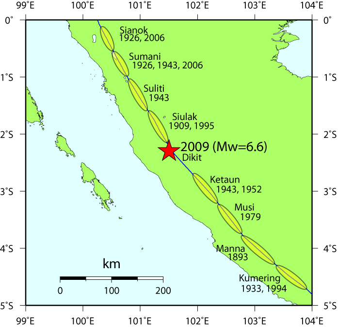
Fig. 2. Recent activity of large earthquakes (M &ge 6) along the
Sumatran fault. The red star represent the source centroid location of
this earthquake obtained from this study. Blue line represents the
surface trace of the Sumatran fault (after Muller et al., 1997,
JGR). The fault segments and years of large historical earthquakes are
after Sieh and Natawidjaja (2000, JGR).
Last update: October 1, 2009
NIED HOME International Seismic Network Laboratory, NIED
|